Quantcast
Channel: parkviews blog
Viewing all 104 articles
Browse latest View live

Looking forward to a special day out

$
0
0
I was quite humbled when before Christmas I was asked by Bulwell's Ridewise project if I would like to do 'a history talk on a bus'. Since then the idea has progressed to the point where it looks likely to happen, thanks to the generosity of Nottingham City Transport.

I suggested that we use NCT's 35 bus route and dug out a NCT bus map from the early-1980s which used to use a cartoon logo called 'Buster'. I was always fond of the little fellow and was sorry when he disappeared from view. With luck and permission, I hope that he will have a role to play in Ridewise's 'History on a Bus' day.

Now this approach was pure serendipity, as I had already started work on my 'HistoryByBus' blog to coincide with my December column in the Nottingham Post, with a view to turning it into a proper website during 2014 (which I still intend to do).


Whether it will be used or not I do not know, but I have created this little logo and I have some other ideas as well, but what happens will depend on how many pennies Ridewise have, but some button badges for children on the the day would be nice.

I have a hand-written list of local history, including buildings, which can be linked to the 35 bus route and it has already reached sixty, with more I want to check out before adding them to my list.

Then a second serendipity occurred. NCT announced that sometime in 2014 double-deck buses will be returning to the 35 bus route, so with luck the two events will happen at about the same time.

At 70 I am ready for more changes than just moving house. I have no committees to attend and my only 'commitment' as such will be to organising the Angel Row History Forums in Nottingham Central Library, which are now in their fourth year, for Nottinghamshire Local History Association (NLHA) in partnership with the city's Local Studies Library.

At some point this blog will take second place to History By Bus, which I see as a prompt to ensure I get out and about more often (by bus of course). Some of you may have noticed already that I posted a entry about the Erewash valley on the new blog yesterday. The map is new, but the rest is recycled material. It is early days yet and I am still working through ideas, so watch this space!

Beeston Connections Bus Map changes and a bus demise

$
0
0
I have updated and made small layout changes to the Beeston Connections Bus Map, prompted by changes to YourBus route Y5, which from 16 February will run via Attenborough Lane instead of Bye-Pass Road on the west side of Beeston.

Also news that Nottingham City Transport's route 14 between Chilwell and Old Market Square will be withdrawn at the end of March 2014, less than six months after it was diverted along Derby Road instead of University Boulevard. This means there will be no NCT bus route between Beeston and the City Centre via University Boulevard, Abbey Street, Abbeybridge and Castle Boulevard for the first time in over eighty years. According to a report in today's Nottingham Post, NCT blame 'increased competition' for the decision to withdraw route 14.

I can understand why NCT have made this decision because of the way 'the market' works, but there is something crazy about the decision, given that NCT is over 80% owned by Nottingham City Council and subsidises other bus routes. This is a case of classic market short-termism. When the Tram starts running it will be so full  that many of us will choose to use buses along the University Boulevard, Abbey Street, Abbeybridge and Castle Boulevard corridor between Beeston and the City Centre and NCT will have thrown away eighty years of service for the sake of a few months losses and its rivals' tenacity will be amply rewarded.

Come 30 March, route 14 will disappear from my map. In the meantime, here is the latest version.


A Lenton walk in the gloom

$
0
0
A few days ago I made a quick mid-afternoon dash to Dunkirk Post Office by bus, but decided to walk back, despite the fact it was gloomy and overcast, with the lunchtime news saying heavy rain was on its way.  It's a short walk I have done countless times over the years we have lived in Lenton, but every time I now do something like this I wonder if it will be the last, given our house is up for sale and in three months we could be gone.


 I have to go to Dunkirk because this is Lenton's only remaining post office, which has to survive with both hands tied behind its back. It cannot issue car taxation disks and many Post Office services have been privatised.  I decided to walk back along Abbey Street to take a look at what was happening around the old Nazareth House site.


On the way, I passed the small Spar convenience shop at the Dunkirk Flyover end of Beeston Road. In recent years, a good few small 'corner' shops like this have disappeared, replaced by supermarket 'locals'. In Lenton, we now have three.


Then it was under the Flyover and along Abbey Street to Priory Street, past two pubs along the way and onto Nazareth Road. The mid-20th century extension to Nazareth House was demolished a good few years ago and replaced by a modern apartment block, but the house stood empty for many years, until finally renovated and turned into apartments.


Nazareth House had been a home for children and then elderly folk run by a Catholic order and a good few of the nuns who served there were buried in its grounds when they died. When the site was re-developed, some of the graves remained in situ and this small fenced area contains their remains.


There is a plaque listing the names of the twenty-seven nuns who died between 1902 and 2001 and who remain here. Steve Zaleski, Editor of the Lenton Times has written several articles about Nazareth House.


I moved on past what remains of the old Cluniac Lenton Priory and onto Gregory Street, where these houses have had to live with Tram works for the best part of a year. As yet no tracks have been laid and on one side of the road work has yet to start. The Tram operating company has said the new line between Nottingham Station and Chilwell will open on 14 December 2014. We shall see.


Turn the other way and you see this. It all looks a mess, but it may be that all the services and utilities under the road have been moved and within weeks work will be finished.


I then continued my walk home along the footpath I long ago named 'Leenside' because it follows an old course of the River Leen, the river which gives Lenton its name. I had it to myself and I like the sense of isolation it gives me, despite the proximity of housing on one side.


This is where the footpath meets the end of Grove Road once you have walked under the railway bridge. The higher bridge carries Abbeybridge road over the railway line. An inner-city corner of Lenton few see or notice.


Once under the railway bridge I turned left onto Hungerton Street, the east side of which has this rather handsome terrace, with the old Lenton Primary School in the distance and the tower of Lenton's Holy Trinity parish church peeking over the roof of the school. Over the years I have taken a good few photographs of the street, usually on sunny days, but, somehow, I like the winter feel of this photograph.


Then onto Lenton Boulevard, where I had previously spied this new tea and coffee shop, which I am unlikely to use, given that I am less than a couple of minutes from home. It had no customers, but I hope it does well. The light was fading fast as the rain clouds gathered again.


This is the long closed New Lenton Post Office — much as it looked when it closed five years ago. A bit of signage missing, but otherwise the same, decaying from the inside out if what you can see of the interior is anything to go by. No one seems to care or comment. The shop with the shutters down closed a good twenty years ago.


By the time I got to Lorna's Florists and Greengrocers, a few yards nearer home, it was well on the way to being dark and an eery blue light had enveloped Lenton Boulevard. A few steps later and I was home and as I put the kettle on to make a cup of tea, the heavens opened. A well timed walk across a small part of inner-city Lenton which I could illustrate with as many photographs again, but every step I now take in Lenton is counted, for my days here are coming to an end and I am beginning to feel the emotional impact physically. People say moving is one of the most stressful things you can do and they are right.

Thirty-five years here is half my life. I have a story about Lenton Recreation Ground waiting in the wings, just another couple of photographs to take...


A quickie post — unbelievable!

$
0
0
A photograph which says more than any words can!


The gate has gone! Finally taken down by The Park Estate, some eleven years after they put  it up to block a historic right-of-way.

The photograph below has appeared in this blog on a few occasions. The photo on the left was taken in 1999, when The Park Estate first announced their intention to block the public-right-of-way between Lenton and Nottingham city centre at this point. The right-hand photographs shows the gate they installed in 2003, but did not begin locking until 2009.

Last year, a planning inspectorate hearing into the order issued by the City Council saying that Lenton Road through The Park Estate was a right-of-way, confirmed the Council's decision. Now, finally, the gate has gone.


Thanks to Gail for the top photograph. After all the posturing by some Park Estate residents it has ended with the Estate removing their gate without any fuss. Quite unbelievable. Is this really the end of the affair?

We shall have to wait and see!

A Bulwell visit

$
0
0
On Wednesday, I went to Bulwell, on the north-west side of Nottingham. It was my first visit in eighteen months and I took my camera with me. My visit was prompted by a meeting with the person organising the history bus outing I mentioned in a previous blog on 1 February 2014.

I now have a time and a date — 11am for Saturday 24 May 2014, when I will lead a history bus tour on the 35 bus scheduled to leave Bulwell Bus Station at 11.27am. The trip will end at Nottingham Central Library on Angel Row in Nottingham City Centre. There will be spin-offs: a leaflet, walks, a 'reminscence map' inspired by a Manhatten 'mapping' website and, possibly, a display of sorts.

I am hoping we will have two folk with us throughout the journey talking in old English, speaking place names as they may have been spoken in 1086, at about the time William the Conquerer's Domesday Book was being compiled (other titles have included 'The Great Survey' and 'The Great Description of England' to name just two, but the title we know it best by is Domesday Book). The 35 passes through a string of pre-Conquest communities, some recorded for the first time in 1086 (there may be earlier references to these places yet to be unearthed by some diligent researcher in the bowels of an archive somewhere).

To hear these place names in Old English is to hear our forebears speak: Bul(e)uuelle; Hamessal; Straelie/Straleia; Bileburch/burg; Waletone/Ol(l)avestone; Lentone/tune and Snoting(e)ham/quin.

In addition, there are two 'lost' Lenton 'pre-Conquest' communities: Mortune and Sudtune/tone (now remembered as Sutton Passeys, the name having been revived in the 20th century). Nine of Nottingham's fifteen pre-Conquest communities are on the 35 route. No other Nottingham bus route comes close to claiming the title 'Heritage Bus Route'.

My visit to Bulwell was made (of course) on a 35 bus, which stops a hundred yards or so away from where I live in Lenton. It really is a journey of contrasts and, as urban bus routes go, epic — nearly an hour in length, with a few hundred yards of countryside and little glimpses of Nottingham's rich heritage here and there, providing you know what you are looking for. Over the coming weeks I will be exploring the route more closely than I have ever done before, For my meeting on Wednesday, I hastily created a blog page charting the route of the 35. Before long the page be no more, subsumed I hope into a new website which Susan is registering for me. So, to have a peek, click here. Some permissions have yet to be obtained, but given it's all for free, there should not be any problems.

On Wednesday I arrived early and for twenty-five minutes wandered up and down Main Street. Here is a selection;


Out of Bulwell Bus Station (which I did not photograph, but I will next time) and straight into Bulwell Market Place. Not the busiest of markets, but still going. Turning to the right...


...beyond the burger van, I took this photograph of Main Street.


At the other end of Main Street is the Mount Zion 7th Day Church of God. The sign also describes it as 'Bulwell Community Church'. I assume that the building was once home to another faith group. Tucked away to the left of the church is a modern building bearing the name 'Tesco Extra'— a temple to corporate capitalism in all its glory.


 Turning back, this was the view of Main Street towards Market Place and on the left is the Wetherspoon's William Peveril public house. This end of Main Street has empty shops and charity shops. One day I will find the time to do a blog about charity shops and how corporate charities are little different to their capitalist counterparts.


Outside the William Peveril pub is this sign. Whilst I was looking at it, a customer having a cigarette came over and said 'They've done a good job have Wetherspoons. They let me in and they won't allow any nonsense. They're good like that'.  He was the kind of man many would avoid, but had I had time I would have enjoyed a longer chat and bought him a pint.


Inside the William Peveril is this statue showing King Harold getting an arrow in his eye at the Battle of Hastings in 1066. The English lost and William from Normandy became the new King of England — the last time we were conquered, but we had the last laugh insomuch as will still speak English and after nearly a thousand years we still take sides and it is never with the Normans!


Just off Market Place is this grim looking alley. It is probably the most unwelcoming entrance to a 'shopping experience' I have ever seen. Sorry Bulwell!  I know you have little control over your own destiny and where what little money there is gets spent, but it would cost nothing for someone to take the wheelie bin in.


And this is what is at the bottom of the alley, two 'Tudor courts' like this. Run down and tired looking despite the fact that they appear to have been built quite recently. In a better off location these retail units would be full of boutiques and 'kupcake' shops.


Outside the other end of 'Tudor Court' there is this clock tower. If I tell you that I took this photograph at 10.50am, then you will realise the clock does not tell the right time. Why did they bother? Money is spent trying to improve the area and great play is made of how great the development is going to be, then once it is open, next to no money is spent on maintenance and the rents set so high that no one can afford to open shops, or if they do, they soon close. Turn 180° and look down a pedestrian underpass under Bulwell High Road and you get a glimpse of this...


...Strelley House, which dates from 1667 and was once a charity school. Behind it somewhere is a dovecote. This is hidden history of the kind the 35 bus history day is all about.


Turning back, I headed into the Market Place again and took this photograph of Bulwell's parish church in the distance, with a side view of  Bulwell Town Hall to the right. Both built on high ground to avoid flooding.


'Flooding?' you ask. Yes, from the River Leen (the same river which flows through Lenton and gives it its name). This view looking north is where it is the Leen disappears for a while, behind shops and under car parks.


Turn 180° and you have a view of the Bulwell Bogs. With a name like that you can imagine the rest for yourself. I have seen this part of the Leen when the water is so high that the water level has nearly reached the road. Admittedly, that was over thirty years ago and flood alleviation work have been carried out since then, but when full to the brim and flowing fast, it is still quite a sight.


By coincidence, all this talk of water brings me to my penultimate photograph, for inside this shop is the well which some say gives Bulwell its name*. It's a lovely story, so well told to me by the shop's owner, Robert Reader, that he has agreed to talk to those coming on the 35 bus ride on 24 May — hence the 11am start, so that those who come along can visit this wonderful cornucopia of household wares and hear something of the well and the shop's long history from Robert. Meeting him and then spending time with Juliet from Bulwell's TravelRight Project made my day.

Bulwell, for all you see, is home to a community not easily cowed. Bulwell has the distinction of electing John Peck, England's last Communist councillor and I was there, on the night, to see it happen and, like a good few other Labour Party members present, I cheered. When the Communist Party fell apart after the collapse of the Soviet Union, he joined the Green Party. John died in 2004, but is not forgotten.

You cannot be a socialist and not have a soft spot for Bulwell.


I left the same way I came. By bus. This time on a 68, which runs a more direct route to Nottingham City Centre than the 35. It was waiting for me outside Bulwell Market Place, just a few yards from the bus station. The name of this bus stop is 'Bulwell Market'— back in 1960 it as also the name of the railway station (and present-day tram stop) we no know as 'Bulwell'.

NOTE: * Local historian Geoffrey Oldfield in his wonderful book, The Illustrated History of Nottingham's Suburbs, begins his entry for Bulwell by saying 'The derivation of the name (Bulwell), according to local legend, is that it was a spring or well, which was started by a bull whose horn struck a large rock from which water flowed. The more prosaic explantion by place name experts is that the first part is an Anglo-Saxon personal name'.

Put this with Robert Reader's tale and then use a visit to his little hardware shop  to kick off our journey into history on a 35 suggests we have the makings of a great day if the rest can be as good! 

Direction and Diversions

$
0
0


First, news today of Tony Benn's passing has filled the media with comment and reminiscences. Those of us lucky enough to have enjoyed his company for just a few minutes have always treasured our memories. We met him on a couple of occasions wearing our Labour Arts & Museums Association (LAMA) hats in the 1970s and 80s. Caroline Benn was one of our supporters. He was always attentive, charming and encouraging. Perhaps more memorable was when he stood on Lenton Boulevard addressing the crowd which gathered around him during the 1992 General Election campaign, when Alan Simpson was elected as our MP. The above photograph is one of a number taken by Susan and is taken from a sheet of contact prints (hence the size). I think this is how I will remember him.

My own wrestlings with mortality seem of little consequence, but I am counting the days to my 70th birthday and I am aware of the direction I want my life to take, but the way ahead remains littered with diversions, mostly of my own making. This does not make me unhappy. Quite the contrary. I feel blessed that I have the energy and enthusiasm. Long may it last.

Trying to sell our house is very much part of where we want to go and the process is made all the more difficult by Nottingham City Council's new planning ban on any more student houses in Lenton, where we live, and other parts of the city. Once again the winners are the landlords and the losers owner occupiers. My next blog will be devoted to what is happening and why the restrictions of Houses in Multiple Occupation is already working in unexpected ways, so watch this space!

Right now, I am working on my new www.historybybus.org.uk website and my 35 'History Bus' day on 24 May, plus preparing for a Lenton local history 'housing' walk with members of West Bridgford Local History Society, and doing some creative writing. Then there are the daily chores. I suspect that everyone reading this lives the same way, except some of you have to work for a living as well.

Finally, just in case you haven't seen it, I am attaching a copy my Nottingham History by Bus Map, part of a work in progress. My direction has been in front of me for years, I love local history and travelling on buses. I have brought them together occasionally in the past and I am amazed that no one else has attempted to do what I am doing on a regular basis. We shall see, but this, along with writing short stories is what I want to do, plus play bowls and grow runner beans in the summer. Then there is loving Susan, still 24 in my eyes and, with her, I feel 24 as well. There will be diversions, most I know will be of my own making, but that's the me I've been living with for  nearly seventy years and I am happy with that insomuch as it doesn't keep me awake at night.


You can see a larger version at my temporary historybybus blog.


A 35 sortie

$
0
0
Today, between house viewers, I took a couple of hours out to do a little exploring in preparation for my 35 history bus tour on 24 May. The map below shows where my sortie took me, plus, not shown on the map, a short hop on a 35 from Wigman Road to Bracebridge Drive shops at the southern end of Bilborough.

It was a perfect early Spring afternoon for walking. Blue skies and a fresh wind reminding me that Winter had not quite yet given up its hold.


The photograph below is taken from the Picture the Past collections of Derby, Derbyshire, Nottingham and Nottinghamshire councils and shows Broxtowe Hall, demolished in the 1930s so that a council housing estate could be built on the land it once occupied.

Its demolition made way for something nobler, grander; these were Labour's aspirations to improve the lives of the working class and they did. This quote from Broxtowe Boy by Derrick Butress, published in 2004, page 7, says it far better than I can:

In the early spring of 1939 (75 years ago)... we joined the exodus of families, most of them from the old slum areas, to the new estates west of the city. Nottingham had an admirable record of slum clearance and re-housing from 1919 until well into the 20th century. (The) Broxtowe Estate was an expression of that pioneering energy. It was built of ugly red brick, but designed with good intent, plotted and planned for a new way of life.

(Derrick Buttress was born in 1932 in nearby Hyson Green, on the northern edge of Nottingham City Centre).

Broxtowe Hall, demolished c1937. See Notts History website.


Two road signs look across towards one another at the entrance to Broxtowe Hall Close, off Broxtowe Lane.


From Broxtowe Lane, you can catch a glimpse of this wall, a remnant of the long gone Broxtowe Hall estate, remembered in the name of a cul-de-sac. It looks very impressive. I will use its location to track down a plan of the estate, so that I can place the wall in some kind of context.


Just around the corner, on Broxtowe Lane, is a small parade of shops. This is one them. Opened in 1958 and still going strong. On my visit I met Ted Clements and his colleague Jason Yates, who grew up in Broxtowe Hall Close and was able to confirm that the wall was part of the pre-war Broxtowe Hall estate.


The council housing built along Broxtowe Lane during the 1930s came in a variety of styles and arrangements, punctuated every so often with lovely looking houses like these, in the 'arts and crafts' style. Others, as below, are arranged in crescents, set back from the road. When I go back I will take a photograph of the City Council sign which says 'No ball game allowed'. Even the most enlightened council can be guilty of what I have long known as 'municipal fascism'. Local historian Chris Matthews, who is working with TravelRight, talks of the estates as being part of the 'Garden City' movement and I agree.


My next sortie will be spending best part of a day walking the length of Wollaton Vale in search of the Nottingham Canal and how the road reflects changing attitudes to housing during a large part of the 20th century. Its post-war council housing alludes to what happened before the 1939–45 war, but never does it reach the heights of this crescent on Broxtowe Lane.


I came across several small parades of shops like this one on Broxtowe Lane and the parade below, only a few hundred yards away, at the junction of Broxtowe Lane and Strelley Road.
Most are occupied. No Costa Coffee or Subways here, though I did see a Greggs on Bracebridge Drive. To the right of this photograph there are some closed up Co-op shops and the left is a Co-op 'superstore'. There are Co-op shops the length of this short walk. They are a topic in themselves. Something for another day.


Being a Saturday afternoon, it may be that this small hairdresser and beauty parlour was closed anyway. I hope so. I like the pink butterflies in the panels and imagine the enthusiasm and enterprise of the person responsible.


A number of Broxtowe bus stops display very large route numbers, like this at the Moor Road stop on Strelley Road.  I have never seem bigger.


Opposite the bus stop, at the junction of Strelley Road, is the sign, pointing to (Bilborough) parish church. To the right a King George post box. It hints at what is to come, something quite unexpected and, I am ashamed to say, unnoticed by me until I came this way on a 35 in January. Thirty years a 35 passenger, albeit occasionally, and there is this...


... delightful Nottingham City Council community centre, known as the Sheila Russell Centre.


To one side, the Centre has its own secluded garden. A rare delight.


A little further on, past some cottages and through a gate, I entered the churchyard of Bilborough's St Martin's Church, It has a modern extension of some artistic importance, but more about that when I have had the opportunity to see inside. For now, enjoy this view of a church at the heart of the original pre-conquest Bilborough. A reminder that people have lived and worked here for a thousand years at least.

Turn around and you look across open playing fields, offering a panoramic view of Nottingham, with tower blocks gleaming in the sunlight. A million miles away or so it seemed for a few brief minutes, then it was off to catch a 35 to Bracebridge Drive shops and to look at a view I have always remembered from travelling on a 35, especially upstairs on a double-decker and why it has long been my candidate for the title of Nottingham's 'Heritage Bus Route'.


As I have said already, the Co-op is everywhere on the Broxtowe, Strelley and Bilborough estates and, by chance, the 1954 Nottingham street map I found included the advert below for the shopping parade above. Windows now boarded up, shutters down, this Co-op parade of shops is a pale imitation of what the 1954 advert promises.


Then I caught sight of this. Yet another small, independent, hardware shop on the 35 route and, standing in the shop talking to its owner, who told me it opened in 1950, I realised what my 35 History Bus Day on 24 May will be about. If you take the time to stop and talk to the folk who live, work and shop along the route of the 35, you experience Nottingham in all its glory, made as much, if not more, by those who live in the shadow of  a 'citycentric' City Council who wield the power.


By chance more than design, this photograph of Wollaton Hall was the first one I took today, from my seat on the 35 bus taking me onto Broxtowe Lane. The 'Bracebridge Drive Shops' bus stop sits across the road's T-junction with Graylands Road and, as my bus idled away a few minutes, I had the opportunty to take this photograph. 

What I have written above about ordinary folk and those who 'wield the power' is a timeless story and is one 16th century Bilborough folk would recognise and understand. Then it was the rich families who owned the land and built the likes of Wollaton and Broxtowe Halls who were in charge. 

This will be my story on 24 May as we travel on the top deck of our 35 from Bulwell to Nottingham City Centre. Quite how I will tell it, is still in the making. Right now I just hope you will enjoy my photographs and this blog.

Lenton Flats

$
0
0
Over the years I have taken a good few photographs of the Lenton Flats. By the end of 2014 all five tower block will be gone. Here are a few:


Notice the test drill holes. They revealed corrosion in the steel wire embedded in the concrete panels which clad the flats. Each panel hanging from the interior steel frame. There weight and mass helped to keep the tower block rigid. It marked the end and it became only a matter of time...


 A view from the flats towards Church Street and the QMC.


A view towards Lenton Recreation Ground.


The Flats from Lenton Recreation Ground.


The Flats at night from 3 Devonshire Promenade.


The Flats from Prospect Place, 2011.


The Flats from Church Street, 2006.


Down To Earth Publicity Poster, 2007.


'The Widow'— a short story

$
0
0
I wrote this 1,500 word story for a friend's 65th birthday this week at her request. She seems to have enjoyed it, although her husband did say after reading it that the next home they buy will be a bungalow...


The Widow
by Robert Howard
for Sue
List of characters (in order)

George Manning.The husband.
Ruth Manning.The wife.
Angus and Robbie.An elderly neighbour and his dog.
May.Ruth’s friend.
Scott and Fiona.George and Ruth’s children.
Alan.The Postie.
Mary Marshall.Read on…

The Widow
For George to be found by his lover was a bonus. Her going to prison for five years was another matter, but there was nothing Ruth could do about that without revealing her part in his death.
It was a brilliantly simple plan.  Her calling ‘George’ from the hall a couple of times. Hiding in the bathroom, waiting for him to leave the bedroom and look down. One push and George was over, with no more than a surprised ‘Whoa’, then a crunch as his head hit the stone flagged floor, followed by a gurgling gasp as he expelled air for one last time.
As Ruth walked down the stairs she was glad George was face down, already a pool of congealing blood around his head. That quick. She picked up the radio cassette and returned it to the kitchen and removed the tape. By the end of the day it would be in twenty pieces and distributed in a dozen litter bins between Fort William and Inverness.
Out the back door, into her car and off. 6am. Bang on time. Angus saw her go. It was his time of day. They exchanged waves, as they had been doing for fifteen years. She slowed down, lowered her window, and asked ‘Where’s Robbie?’
‘Ach, I left him in the hoose. Not long now’.
Ruth would miss them both. Angus was one of the church elders who had sold them the manse. Now in his late-eighties, Angus was the only one left and Robbie, his collie, even older (in dog years that is). As she drove away from Angus, the words ‘Not long now’ lingered. 
It was a two-and-a-half  hour drive to Elgin along the A82 and A96, with a welcome break for a quick breakfast in Inverness, where she was picking up her friend May. Her head a maze of jumbled thoughts. George kissing her goodnight in bed, snuggling up and promptly falling asleep. Who would tell Scott and Fiona? God they were common back then. Working class through and through, dragging themselves up by taking every opportunity life threw at them. Somehow, George had gone from waiting tables to running a catering company supplying oil rigs, whilst she had done a ninety-degree turn from being a hairdresser to running up-market craft fairs with May. Business was good. Golfing wives always had lolly, lots of it, so they were looking forward to a good two days in Elgin. Back came the kids. One in Edinburgh, the other Plymouth. They would come immediately and she would send them away as quickly as she could. This was between her and George. None of their business. So the journey went. She stopped at eight lonely lay-bys on the A82. No one saw her. A brown paper bag with a length of tape and a piece of the cassette into each bin. 
Either she would find George or someone would call in. Alan the postie most likely. He often stopped for tea and a  chat. A welcome break on his long rural round. If they were out Alan would let himself in, make a drink and use the loo.
Breakfast with May went well and, by the time they arrived in Elgin, Ruth had convinced herself that Alan would find George. Someone would eventually go into her workshop and see ‘Mansion House’ written on her calendar against 7th August. It might take a few hours, but they would find her.
What Ruth had not expected was for Alan to see Mary Marshall of all people drive past him at such a speed that he had to swerve to avoid a collision. The Police quickly established that George and Mary were in ‘a relationship’. The night before he had not closed down his computer and there, on the screen, was an exchange of e-mails, with George saying Ruth was away overnight, so she could come to the house. Mary had replied that she would come over after dropping the children off at school.
Mary admitted to finding George dead and told the Police hat she didn’t dial 999 because her husband would want to know what she was doing at the house. She denied any ‘relationship’ with George and said that he visited her office in Fort William once a week to go through the factoring work she did for him and that, occasionally, they would have lunch.
In George’s home office the Police found items of underwear, and traces of DNA on his day-bed,  all belonging to Mary. Her denial of any relationship with George, given that they shared an e-mail account, only fuelled Police suspicions. 
Ruth rarely went into George’s office. He was so meticulous. He did the ironing, folded his own clothes, planted the borders, bought the wine. When they first met  and went to football matches, they would joke about how football teams reflected the personalities of their supporters. She was all kick and run like her beloved Crystal Palace, then a top goal scoring team. It didn’t matter that they let more in. George liked a passing game, building up to perfect goals, and in those days no team was better at this than his Leeds United.  So it was in bed. Him, in control, teasing, nibbling, always the long game, whereas she liked it quick, then again just as quick. She enjoyed the urgency.
‘Mary Marshall, Mary bloody Marshall’ was all she could hear herself saying. She was just a name. Ruth only knew her as George’s book-keeper. It wasn’t the reason she killed him — thirty years with a control freak was the reason. She wanted to go out without giving a reason; take off her clothes and leave them where they fell. The rest she could take. At fifty-seven she wanted some abandonment in her life, especially in the bedroom. The clock was ticking for her just like it was for Angus and Robbie.
Mary Marshall’s husband didn’t help her case. He suspected she was having an affair with someone and had, only a few months previously, questioned her closely about why on one occasion, when he watched her undress, she was wearing no underwear.
During interrogation, Mary finally admitted to her relationship with George and said that she was trying to end it, but he was threatening to tell her husband. Neither of the latter statements were true, and from there on, the Police built up their case. Mary’s trial lasted five days, during which the time the Prosecution argued that her final, fateful, meeting with George did not go as planned. They argued and Mary pushed him, albeit without intent to kill, but since George ended up dead, it was still murder as far as the Prosecution were concerned. It was all enough to get a conviction, but thanks to the Sheriff’s direction the Jury brought in a verdict of involuntary manslaughter.
No Prosecution suspicion fell on Ruth whatsoever and she attended Mary’s trial as a witness only to state that she had never met the accused, nor did she know of the affair. Mary’s Advocate questioned Ruth closely about her relationship with George for thirty minutes to no avail.  Ruth never looked at Mary once. She didn’t see the tear-stained face of a woman so sedated that she was incoherent when she spoke, but she did hear the sobs of disbelief. This wasn’t happening to her. It was happening to someone else. 
Alan was the one who caught what headlines there were with his graphic description of Mary leaving the scene at great speed and how George and Ruth were the perfect couple as far as he was concerned. The Police did explain to Ruth that they would have to look closely at her marriage and their personal lives and Ruth said that she understood. 
The Police did ask about May, noticing that whilst  at the Mansion House Hotel in Elgin they had intended to share a room overnight. Ruth pointed out that they had been doing this since teenagers, when they lived in South London. Both had ended up in Scotland by chance and, away from their families, they remained close friends.
Mary Marshall was released on licence  two years later,  by which time Ruth was living in Cornwall, having moved there a few months after the trial. This seemed understandable to all who knew her, especially since her daughter Fiona lived in nearby Plymouth and was, at the time, expecting her first child. May visited and each stay was little longer, until she sold up and moved in with Ruth. Alan came too, not long after his wife died of cancer, and eventually moved in as well. The locals gossiped, but at sixty Ruth was enjoying life as a widow.
What feelings of guilt Ruth felt about Mary had dissipated quite quickly and she lost no sleep over George. No one would ever know the truth: that she, Ruth Manning, a respectable sixty-year old widow had got away with murder.

The End

An Aspley walk with TravelRight

$
0
0
On Saturday 12 April, I took myself off to Aspley on the north-west side of Nottingham to go on a local history walk organised by TravelRight and led by local historian Chris Matthews. The map below shows the route we followed.


My photographs come with minimal information because TravelRight have published an excellent leaflet about Aspley, Broxtowe and Cinderhill called Garden City by Chris, which he has also written about on his own blog page, which you can download here.


There is another leaflet about Beechdale, Bilborough and Strelley, called A New World, also by Chris, which you can link to here.

Chris Mathews also has a wonderful website at: localhistoryandart.com.

It is amazing how many times localhistoryandart crosses over my own interests, from CLASP architecture, something I wrote about in The Nottinghamshire Historian in 2010 and 2011. I then buy a copy of collection of essays about Ian Nairn, published by Five Leaves, only to find that it was designed by Chris. Without doubt, he is the most innovative local historian I know.

The walk began and ended at Aspley Library, at the junction of the Melbourne and Nuthall roads. Inside there is this wonderful roof-light. I took this photograph by laying on the floor. 


Aspley Library opened in 1937 and reflects a style I love. I see it as 'democratic', insomuch that it was intended for everyone. Nottingham City Council was saying to the world 'Nothing is too good for our people. We will build them new homes and places of learning and leisure to match'. That is what Aspley Library and countless others said. And can say so again, given vision and leadership.

The walkers gather. I am in there somewhere, as a young man called Andy kindly took this photograph.

Chris Matthews shows us where we will be walking.

Looking at the route he plotted with a blue felt pen, it did seem a little ambitious. Chris is one of the best local history walk leaders I know and back in 2008 (that long ago!) I wrote a two page lead news story in The Nottinghamshire Historian (No.81 Autumn/Winter 2008) headed  'The first of a new breed of Nottinghamshire local historians?' He brings to everything he does a great deal of research and scholarship. I have watched him enthrall young audiences coming new to local history, hanging onto every word.

Looking around the group, I suspected that a good few would be bringing their own knowledge and reminiscences to the walk and that this would slow the pace down considerably. This was going to be very much a learning walk for everyone and so it turned out to be.

Here is the TravelRight Walking Group, getting ready for the off.
We got no further than the bottom of the steps, before we were looking at Aspley Library's foundation stone. I intend to add a photograph of this next week. After any walk, you realise there are opportunities you missed in terms of taking photographs or making notes.

At the time, I was thinking about how vandals and authority collude against the rest of us. This fact is captured perfectly in this photograph. No doubt the truly awful 'artful' metal security grills over the window (and others) have been installed as protection against vandalism. The equally awful green signage, on the other hand, does not have to be there. The fine stonework above the entrance could have been cleaned far more cheaply and says, in large letters, 'BRANCH LIBRARY', so why, oh why, the awful green signage? 

It also tells you a great deal about the mindset of those who manage and make decisions on our behalf. They have to 'brand' everything. They are no different to those who have to spray their 'tags' on every wall.


Melbourne Road from the side of Aspley Library. Remarkably quiet and free of traffic for a Saturday afternoon.

The Walking Group crossed over to lefthand side, as the entrance to Melbourne Park is on the left side of the road.


To the side of the house you can see on the righthand side of Melbourne Road and the righthand edge of the above photograph is this cut-through, a public footpath following the course of what was once a mineral railway.

Several of the older walkers said the railway was still being used at least once a week in the 1960s to deliver coal to coal merchants.


Looking south across Melbourne Park to St Margaret's Church on Aspley Lane.


The Park pavilion is still used by footballers and there were several matches being played as we walked though the park.

Again, it is depressing to see a fine public building like this surrounded by a high metal fence and all the windows boarded up.


On the east side of Melbourne Park are two rows of tall trees. I love how they have been shaped by the prevailing wind. How they all bend to the east.


The same trees again. The gap between them and the fences of the back gardens on Newlyn Drive is where the mineral railway to used to run, when it was the park's north and eastern boundary.


We walked out on to Newlyn Drive and turned left and followed the road to the Ring Road and its junction with Nuthall Road, which then walked along until we reached Aspley Library again*. To it's right, we turned off the Nuthall Road, with TravelRight's own xxxx bringing up the rear, making sure that no once got lost or left behind.

NOTE:* On the map this section is not shown.


Then we were back on the line of the old mineral railway again, away from the noise of Nuthall Road.


Not far away in the grounds Christ Church, Cinderhill, I came across Bluebells and a good few of them. I will be going to Oldmoor Wood in the next week or two to see a display of Bluebells as good as any and I will be getting there on a 35 bus!

Across Bells Lane at its junction with Nuthall Road and on towards Cinderhill Island, the first of two churches. This former Methodist Church now a Age UK centre.


Christ Church, Cinderhill, which sadly has no churchyard of its own. Old gravestones tell their own stories and give a glimpse of a world we can never, truly, know.


This was described by one walker at the old Christ Church Hall, but on the 1954 map at the top of this blog it is marked as a 'school'. I suspect the 1954 map maker picked up a reference to a Sunday school — something which went on in most church halls at one time.


Turn 180° from the Hall above and you are on a footpath leading to Basford Miners' Welfare Club. To the left is this pocket of open space. It just takes one line of trees to deaden the noise of Nuthall Road.


Then we are at the Miners' Welfare Club, once Basford Hall. The core of the original house can be seen and you get an idea of its lovely proportions, despite the protruding extension and smokers' hut. Nearest the camera is a more recent extension dated 1996.

At one time, I knew the Club quite well and was a regular visitor during my days as a councillor for what was then Portland ward. This was where all Party meetings ended — need I say more?

It was during this time I became a regular user of the then newly introduced 35 bus service to Bagnall Road and The Headstocks public house. Two friends lived close by. When I stood down as a councillor in 1985, my use of the 35 became only occasional, but I appreciated it enough even then to know that it was a very special bus route, right up there in the pantheon of English bus routes.


From here we walked through a modern housing development to Bagnall Road and its junction with Cinderhill Road, where we took the path down to the Cinderhill tram stop and the footpath beyond to the Phoenix Business Park, where I snapped a tram as it trundled towards us. It wasn't until I downloaded the image into Photoshop that I noticed the driver waving.

At Phoenix Business Park we stopped to look at this commemorative plaque from 1994.

                             
One of walkers said that in the garden attached of the Miller's Barn restaurant at Phoenix Park was the remains of one of the old mining shafts at Cinderhill Colliery and the manager on duty kindly let us all go in and have a look. To me, it looks more like a folly than actual remains, as if someone has piled stones on top of one another and cemented them together. Inside the restaurant has exposed brickwork made to look like what remains of an old engine house. However, I tend to fall into the writing camp which says 'Never let the facts get in the way of a good story', so I am happy to believe that we did see the remains of an old pit shaft at Cinderhill Colliery. Why not pay them a visit and have a good meal whilst you make up your own mind.                                                                             


Across the Nottingham Road and still in view of Phoenix park is the entrance to Broxtowe Country Park. When we started out, Chris had this down as our mid-way point, but after two hours, members of the group were getting tired, so the decision was made that we would head back to Aspley Library straight down Nuthall Road.

The second part of Chris's walk will probably make a good walk on its own. In the meantime, I will try to find the time to complete it on my own. 

Back at Aspley Library there was a toilet, in this order, food and nice comfy seats to sit and watch old films of Nottingham's 'Garden City', which meant that Rebecca Beinart's innovative reminiscence mapping table got less attention than it deserved, but there were a few interested folk, like Michael and Joy (right).

Those taking an interest wrote their contribution onto a Post-It note and stuck on the map. Even with just four or five people (some did not want to be photographed), every Post-It note sparked a discussion, which demonstrated what I already knew from reminiscence work on my part dating back over thirty years. Something like this needs a day, not the hour it had become because the walk was so successful.


I will end with Hilary pointing out one of the myriad of changes which others had missed or forgotten. My own contribution was a note Rebecca wrote at my suggestion marking the location of the Old Basford High-rise Flats Complex. Close enough to appear on the map, but forgotten until mentioned by me. The whole mapping session was a co-operative effort and I hope it will be repeated, but next time as a day on its own.

Well done to TravelRight. They really are tackling local history in an innovative way in the one part of Nottingham that does not have a local history society to call its own, apart from Basford, Bulwell and Nuthall. If all this ends with a local history society or group being formed for Aspley, Bilborough, Broxtowe and Strelley it will be a result for TravelRight.

In search of the abandoned Nottingham Canal Part 1

$
0
0
On Good Friday I left Susan at home finishing off seven weeks work creating a new version of the Nottinghamshire Local History Association website whilst I took myself off in search of the abandoned section of the Nottingham Canal between Wollaton Vale and Trowell. The map below shows where I walked (the section from Trowell to Langley Mill will be another walk).

1. I went to Wollaton Vale on a Nottingham City Transport 35 bus from Lenton and got off at the Grangewood Road stop. You can just see the 35 disappearing in the distance. The stop is over a pedestrian tunnel which follows the line of what use to be the Nottingham Canal if my 1954 Nottingham street map is correct. Then, all this was open farmland.

2. This is the footpath beside Grangewood Road viewed from photograph/location 1. It is following the line of what was once the Nottingham Canal.


3. In a couple of places along Grangewood Road there is what I can only describe as 'street sculpture'. It all very attractive in its way. If I had my way I would have a lot more public sculpture in our streets and parks.

4. Where Grangewood Road meets Latimer Drive you can look across and see this sign. It is the eastern entrance Nottingham Canal Local Nature Reserve and is right on the border between Nottingham City Council and Broxtowe Borough Council.


5. As you can see there is an excellent footpath which follows the line of the abandoned canal through what is now woodland.


6. The footpath follows the line of the canal and this is the first point where there was any water to be seen. Here it passed under the railway line which runs between the Trowell and Radford junctions. In the late-1988s the then British Railways proposed closing the line. Susan and me were part of a successful campaign by Transport  2000 (now the Better Transport campaign) to save the line.
7. At the western side of the Nature Reserve you have to cross Coventry Lane to continue following the line of the abandoned canal.


8. One of a number of Erewash Valley Trail information boards there are along the walk.
9. For a short distance sections of the old Nottingham Canal have water in them. Most of the walk though, the old canal in no more than a depression beside the footpath.

10. In places the footpath is slowly becoming a tunnel of greenery.

11. This was the first sitting place I came across. I rather like how stone blocks from the canal have been used to create more seating.


12. The first of two old canal bridges still in situ.  It may have once led to a farm marked on a old map as Swancar Farm.
13. The canal bridge is no longer in use and offers  views of the surrounding countryside.

14. The branch railway I mentioned under photograph 6 runs to the south of the footpath and just one train trundled by as I walk along. I caught this glimpse of it.

15. The first people I met were Millie the dog walking her friend. She had dropped her ball down the bank and I caught them as they struggled back onto the footpath after a unsuccessful search.
16. The footpath has to divert around the Trowell Garden Centre, an ugly collection of sheds, but it does have a loo and a café, so I am not going to say anything other than that its signage was its most attractive feature. After this point the walk, sadly, becomes unsuitable for wheelchair users and buggy pushers.
17. Just by the sign in photograph 16 above, there is this gate to the footpath which wraps around the garden centre.
18. On the far side of the garden centre, you come to a footpath crossroads with just two signs, although there are four routes.
19. In fact, there appears to be only three paths at this point, this being the third footpath. It is another old canal bridge. Immediately to the left, before you go over the bridge, there is a slope leading down to a grass footpath beside what remains of the Nottingham Canal at this point.
20. Not far along the footpath there is this sign. 
21. A few yards further on you come to this pool (or is it a pond?). It is the largest expanse of water you will see on the walk and there is a bench overlooking the pool, which I was sitting on when I took this photograph.
22. At this point the footpath had just dipped so that it could pass under the M1 Motorway alongside the Nottingham Road. I took this photograph looking back and you can just make out the Motorway bridge through the trees. The number 'TWO' Trent-Barton bus stops right beside the bridge and the name of the stop is 'Motorway Bridge'. It is here that wheelchairs and buggy pushers can rejoin the walk.
23. This section of the footpath runs in a shallow loop between two points on the Nottingham Road and is probably the longest stretch where a clear imprint of the old Nottingham Canal remains.

23 extra. Peeping out from among the brambles, across from the footpath, is this warning!

24. Then you dip down under the Nottingham Road on the edge of Trowell. The top of the bridge at road level appears original and may have been constructed using reclaimed stone, but the path its self is new and what remained of the canal filled in and concreted over.

25. A rather grubby sign marks the beginning of this section of the footpath on the north side of the Nottingham Road.

26. This sign close by is altogether cleaner, although there is evidence to suggest that at least one bird has had a close look.

27. This section of the footpath gently curves for about half-a-mile until it reaches Grange Wood on the eastern side of the footpath. It did make me wonder if the 1960s road off Wollaton Vale where this walk began had any link to this wood.

28. It is here I had already decided to end my walk along the line of the old Nottingham Canal. I will come back here before too long and finish following the footpath to Langley Mill, where the canal met with the Cromford and Erewash Canals.

I love the fact that the sign simply says 'Shortcut', but not to where!

I should also say that this is not a good place for wheelchair users or buggy pushers to end their walk...


TO BE COMPLETED TOMORROW


How do you to build a tram system single-handed?

$
0
0

I took this photograph on Tuesday 29 April at about 1pm walking into Beeston after a visit I organised for Nottinghamshire Local History Association to Hurt's knitwear factory near the Barton Gallery and opposite what is now the Beeston Annexe of Nottingham Central College.

I have long been of the view that those working on constructing the tram line are like Starlings. They seem to flock and swarm about in patterns as they hurry about doing what seems like nothing in particular. They must be doing something, because the landscape changes and the fact that tram track is slowly, but surely, being laid is evidence of the fact.

If I had had the time, I could have taken a series of photographs to prove my claim, but I just had time for one — eighteen men milling around one short section of would-be tram track. Perhaps it was a training session of some kind, but what struck me most was how many of The Tram workman I saw on Tuesday were clutching mobile phones,

I am a regular visitor to Beeston and the Beeston end of Chilwell High Road. At least once a week, often twice. Since 1996 my wife and I have been visiting Caritas, opposite the police station, and shopping at the Local Not Global Deli regularly, as well as occasional visits to other shops along this section of the new tram line to Toton, which has been under construction for a very long time.

At the end of the day I believe The Tram to be a good thing, although I am sceptical as to what benefits it brings to the communities in Nottingham it passes through. Bulwell and Hyson Green bear witness to the fact neither shopping area appears to have benefited one iota ten years after the first tram carrying passengers trundled by. I have a nasty feeling it will be the same for Beeston. I sincerely hope that I am wrong about this. We shall see at some point in the future.

A little further on, I saw a Tram worker down a deep hole close to Imperial Road. Only his head was above the hole and he was shouting profanities at three men, all in yellow coats, all holding mobiles, staring down at him. What I caught went something like this: 'I'm the one in this f**king hole, so why don't you let me get on with my f***king job, instead of coming here ever f**king minute to check up on me'.

If you read this post and see the Nottingham tram extensions under construction, check how many workers are holding mobile phones. The work does seem to be a good way behind schedule and I will be full of admiration for all involved if the whole system is up and running for the oft-repeated starting date of 14 December 2014.

Given how long it has taken them between Middle Street and Holly Lane so far, it will be next year sometime. Maybe the delay is being caused by managers behaving like children, forever checking up on how construction is progressing — a bit like children on a journey forever asking 'Are we there yet?'

Commonsense says if you want to build a tram line fast, then let the workers use both hands.


Poster buses, with a nod to Chris Matthews

$
0
0

Chris Matthews has designed this great poster to advertise TravelRight's History By 35 Bus event on 24 May 2014. Beneath is a nod by me using a now vintage bus instead to be my bookends.


When we could fly – a walk around Bilborough and Strelley with Chris Matthews and TravelRight

$
0
0

I am an experienced urban walker who has been publishing walks and leading them for a good few years. In three weeks I will lead my last ever Lenton history walk, for when we move my interests will be elsewhere. It may seem an odd thing for a person with a passion for local history to say, but I only look back so that I can see the future more clearly.

Chris Matthews's TravelRight history walk around parts of Bilborough and Strelley on 19 April was a perfect example of this. Once we could fly and we still can. We are peddled lies as truths, and far too many believe the bankers and politicians who try to deny us a future of our own making. More of this later. Now, let us begin...


1. Bilborough Library, off Bracebridge Drive by the shops is where we gathered for our walk.

How different to Aspley Library where we had started the previous week's walk.

Brutalist and ugly. A fortress in looks. but a palace to learning inside, even though the lobby was cold and stark. Bilborough deserves better.


The Walk Group gathers around the Library's mosaic. A lovely idea at the time, but now neglected and in need of repair.

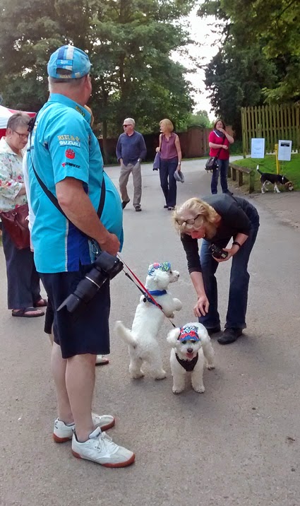
As you can see, we were a motley bunch, affable and eager to be off.


 Chris Matthews, our Walk Leader, tries to show us the route. We look on and nod knowlingly. No one has the heart to tell Chris he is holding the map upside down. The important thing is that Chris knows where he's going. He told me later that he had rehearsed the walk the day before.


2. Darnhall Crescent, with Chris explaining the historic and social importance of the BISF houses across the road. They were prefabricated in old aircraft factories by the then British Iron & Steel Federation in the years after World War Two, when there was a desperate housing shortage.

The houses were erected very quickly sixty–seventy years ago and whilst many are now in a poor state of repair, others have been cared for and cherished.

The Tory policy of allowing council tenants to buy their homes (and not stopped by Labour once in power) was, for the most part, a bad thing, but looking at these houses, you can see that the policy probably saved these houses from demolition.

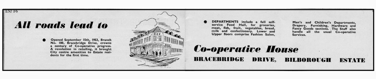
 3. Bracebridge Drive shops. The Bilborough Estate has an impressive shopping centre built in the early-post-war years. The then Nottingham Co-operative Society was central to so many of these schemes. The first floor windows are boarded up, but I suspect that once there were meeting rooms on the first floor, where different Co-op organisations met.

Below is an advert I found in a 1954 Nottingham street directory and map.


I have used this photograph before. The 35 bus stop at Bracebridge Drive shops looks across to the photograph above of the Co-op and, if you look straight out of an offside bus window, this is what you see — a view straight down Graylands Road towards Wollaton Hall.

I doubt if present-day Nottingham Planners would have the same eye for detail. They seem to know little of Nottingham beyond the City Centre.

It has been one of my favourite views since c1983 when the 35 bus started and I began using it to travel regularly between Lenton and Cinderhill (a story for another day).


4. St John's Church on Graylands Road, just down from the Bracebridge Drive shops.


A close-up of the church tower, with its fine mosaic mural. I wonder if the mosaic outside Bilborough Library is a reference to this one?


I like the simplicity of St John's Church and its interior. Restful, as all faith buildings should be.


St John's has scenes depicting the Stations of the Cross on dotted around the church. Until this visit, I had always thought there were twelve stations, but this is no.14.

I am not a religious person, but there have a pleasing appearance and texture.


Two of Bilborough's three Labour Party city councillors were with us for part of the walk. Wendy Smith and Marcia Watson. Their colleague Malcolm Wood was unable to make it. Malcolm is a little slower than he used to be and was the first Nottingham city councillor I ever met, back in the mid-seventies, when we were both very young Labour Party councillors. I was on Birmingham City Council and chaired the then Midlands Area Museums Service, which covered both the East and West Midlands.

The last couple of occasions Malcolm and I have had a chat has been on a 35 bus, so I hope he is going to make the History from a 35 Bus Day on 24 May, which I am leading for TravelRight.

I hope Wendy and Marcia will be there too.

5. Staverton Road offers this rather impressive side view of St John's. Notice the pale blue 'fins'. These can also be found on the Graylands Road elevation, which you can see in a previous photograph. They are said to represent aeroplane wings and you will see this architectural feature again before the walk is over.

The chapel extension to the left end was, for a while, used for church services.


After World War Two, large estates of single-storey 'prefabs' became commonplace and were highly sort after by would-be council tenants. As a child I had an aunt and uncle and cousins who lived in a prefab. It had a fridge, electric heating and all mod cons. They were demolished years ago, but Nottingham is one of the few place where prefabs never really disappeared and their footprint remains, albeit with a modern outer shell. In many places, like these off Staverton Road, they were reached by footpaths. Few folk had cars then.

This is the post-war prefab as I remember it. I took this photograph a couple of years ago at the Avoncroft Museum of Buildings in Bromsgrove, Worcestershire, a place I know quite well for a number of reasons and have watched it grow ever larger as more and more historic buildings have found a new home at Avoncroft.


Still on Staverton Road, across from the previous photograph, is this terrace of council bungalows, more conventional in style and pleasing to the eye.

I suspect for many a prefab is the preferred choice, because they are detached.


6. Chetwin Road close by shows off another kind of mass produced post-war housing. This time made of concrete.

This photograph shows one in the process of being clad  to improve insulation and to extend its life for a good few years yet.

Chris Matthews's leaflet for TravelRight, a Walking & Cycling Guide (to) Beechdale, Bilborough & Strelley, has a section devoted to pre-fabrication. Well worth getting hold of a copy if you don't have one already.

7. Westwick Road's  access to Birchover Road Recreation Ground is good place to show a small architectural feature common to the entire estate. When the houses were built, two kinds of porch door canopies were used. Look closely at the photograph and you will see what I mean.

Which one do you prefer? The one on the left or the one on the right?


8. Birchover Community Centre on Birchover Road is another brutalist building. I have not been inside, so I will reserve judgement until I have.

I am in no doubt that the appearance of buildings in our townscape do impact on our social behaviour. Architects and planners rarely conduct their experiments in social engineering in middle-class suburbia or rural commuter land.

I want to like it. Perhaps I will.
Opposite the Community Centre, the walking group passed by a 35 bus on Nottingham's unofficial 'heritage bus route'. My photograph gives the impression that there is a long queue for the 35 and I have already used the photograph elsewhere claiming as much.

Local history and the media, a bit like showbiz, is about story telling — hence my belief that you should never let the facts get in the way of a good story.

Soon the 35 will have double-deckers again.

9. Portland School entrance off Cockington Road. Notice those aeroplane fins again, just like those on St John's Church.

A fine Council building from a time when we had the confidence and vision to fly. Nothing was too good for the working class under Labour from the 1930s–1960s, then the Party got cold feet and reformist leaders. Nottingham folk still believe we can fly. There is hope yet.

10. The beginning of Strelley Lane, off the west side of Bilborough Road, heading north towards Strelley Village, yards away from a 35 bus stop and countryside all around.


11. Strelley Lane becomes a bridle path, where this barred gate blocks off vehicle access.


Across to the west the view is open countryside.


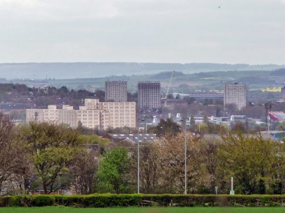
To the east, a vista of Nottingham towards Lenton across open fields. The large white building to the left side of the photograph os the Players warehouse at the junction of Wollaton and Triumph roads.

Beyond, only three of Lenton's high-rise blocks of flats remain. Two have gone in the past year. All will be gone this time next year.

Beyond, hidden from view, is the Trent with a hint of the Vale of Belvoir beyond.

12. Strelley Lane bridle path at its junction with a footpath west towards Trowell Moor, where we are passed by two horse riders.


13. Looking south down Strelley Lane from Main Street, Strelley.


14. Strelley Hall, viewed from Strelley Lane at its junction with Main Street.


Having looked at the Hall, the walking group hot foot it towards Strelley Church. Legs are getting tired now and the walk is well past the time by which it should have finished, but we have someone waiting for us at the Church...


15. The gate to All Saints Church, Strelley, with the Hall just visible.


16. All Saints Church. Inside the Church Warden is on hand to talk to the Group about the Church and its history.

The Church Guide says it 'probably dates from the mid-12th century' and is not mentioned in the Domesday Book of 1086, which does have an entry for Strelley. The Saxons who lived here 'more likely worshipped outside at a stone cross, the base of which still stands in the garden of Fountains Cottage in the village'.


 On a Church wall there is a photographic display of what visitors should look for inside the Church.


The altar is very different to St John's in Bllborough, where we had been a couple of hours before. Churches like this are like roses to me. I am glad that they exist and that someone else looks after them and I happily donate when I visit, but I would not like to come here every Sunday.


All Saints Church has many fine features, but the star of the show must be the alabaster tomb of Sir Sampson and Elizabeth de Strelley dating from 1405–10.

Truly wonderful and notice they are holding hands. This alone makes All Saints Church a national treasure. A must visit church within a few minutes walk of a 35 bus stop.


Finally, a simple memorial plaque, much more to my taste, to Emily Edge. The following quote from Broxtowe Boy (pub. 2004) by Derrick Buttress I have used before, but it seems fitting to use it again:


Strelley Hall (is) a grey Georgian mansion guarded by high walls and locked gates. Inside lived Miss Edge, an elderly spinster with time on her hands and many acres of parkland to spend it in.

She once spoke to me and was kind, pleasant and straight out of Jane Austen. She asked me what I did for a living. When I told her I worked in a factory, she related that she, too, had visited a factory. Once’.


17. 'The Moat'. Long shown on maps as a 'moat', which many to take as meaning that the site was once protected, if not fortified. I have my doubts. It could be no more than the remains of an old quarry.

Perhaps some time in the future there will be an archaeological dig to find out just how old the site is.


18. Main Street, Strelley, has a number of cottages along its length, of which this is a typical example.


19. Remains of an industrial landscape. Walking through Strelley in 2014, it is hard to imagine it as it once was, five to six hundred years ago, a landscape dotted with bell pits and at one end of the world's first recorded railway, constructed in 1604–05 between Strelley and Wollaton to carry coal.

In the middle of the photograph, just in front of a lone, dark foliaged, tree is a depression. It is the remains of a bell bid, from which coal was taken until it was no longer safe to do so, then another pit would be dug.

20. Broad Oak Pub, Main Street, Strelley, where the walk came to an end. Originally Chris intended to take us into old Bilborough Village and then back to Bilborough Library.

The walk had been lively and full of chatter — always the sign of a good walk — but legs were tired and folk were feeling hungry and, as I well know, the Broad Oak does great fish and chips. Need I say more.

Well done Chris, another great walk and thanks to TravelRight for their support and encouragement.

I hope you have enjoyed the walk with me.

Where to spend a 70th birthday

$
0
0
It is just over five weeks since my last post, during which time a lot has happened, some of which you can find mention of at my History by Bus website. Other highlights have been finding a house, then losing it, then finding another one better suited to our needs, not least being that it is in Beeston, within a short walk of the town centre. Top of the list has to be my 70th birthday, which began a few days before the 16th and ended a few days after, with a string of enjoyable lunches with old friends, family and former work colleagues, even though I retired eight years ago.

So what do you do on your 70th birthday? I chose to spend it in Stoke-on-Trent having an early lunch (what else?) with close friends, then going on a visit to the gardens at Biddulph Grange, just north of Stoke. I will let a selection of the pictures I took tell their own story.


Biddulph Grange is actually a collection of themed gardens which remind me of different things. The long gone dells of Barham Park in Wembley, where I went to the local library and along winding, hidden, paths, or the lawn and view to the 'big house', where we had tea. There is also a hint of Gunnersbury Park in Ealing, my favourite park as  a child in the fifties. Above all, it was feeling alone with close friends. For a few hours nowhere else existed. That's what I call a birthday. As ironic as it seems, timeless.

The picture below offers a different take on the day and is a compilation by Rosie, a close friend and champion blogger, who persuaded me to start blogging in 2007, which is when I started parkviews.blogspot. Rosie's blog is called Corners of my Mind.


There is a lot of me, with one exception, snapped unknowingly, so here is one of Rosie (which she knew I was taking whilst we waited for our other halves to fetch the tea and cake at Biddulph Grange).


Rosie also took one of my favourite photographs ever when we were all coming back a few years ago after a visit to Stratford-on-Avon. Rosie took it at my request, after I asked the permission  of the couple in the photograph. When we have moved, I plan to have a copy enlarged and framed to hang in our new house.


I reached 70 achieving one ambition at least (we had intended to move last year, but a small stroke and a poorly cat, the blessed Markiza, put that plan on hold). I reached 70 on no committees and no memberships of anything, save Nottinghamshire Local History Association, who kindly humour me, by allowing me to do my own things in their name. From now on I help where and when I want and donate instead of join.

There are postings of walks waiting to be done, when I find the time. The process of moving after thirty-five years in the same house is time consuming, so please bear with me. I am planning a tour of Beeston parks come late-summer, so that the title of my personal blog continues to have some meaning. 


Bobbers Mill TravelRight Walk

$
0
0
A very late post recalling a great TravelRight walk on Saturday 3 May 2014. As the pictures show, it was a lovely day. Another walk which took a lot longer than intended, but even when walking across derelict land, there were things which caught the attention.

Our walk leader Chris Weir was a Principal Archivist inNottinghamshire County Council Archives until he recently retired. He is also Vice-Chair of Nottinghamshire Local History Association. Chris is a popular walk leader and has a galaxy of asides which he can drop into any talk or conversation about local history in Nottingham.


The walk started from St Stephen with St Paul's Church. Chris said the first church on this site in the 1880s was named St Luke's Mission Church, then it became St Simon's before becoming St Stephen, with St Paul's added when a nearby church of that name closed.

The following extract from the Southwell & Nottingham Church History Project provides more information:

St Stephen’s, on Bobbers Mill Road in Hyson Green, Nottingham, was the successor church to St Stephen’s, Bunkers Hill. It was consecrated by the Bishop of Southwell on Ascension Day 1898. The church was built to serve a working class community which grew up in northern Hyson Green during the 1880s and 1890s, while St Paul’s, Hyson Green served the southern part of the area. Hyson Green was extensively redeveloped in the 1970s and 1980s. and with the development of low density housing, the two parishes declined in numbers. In 1987 they were amalgamated as the joint parish of Hyson Green St Paul’s and St Stephen’s, Nottingham. St Paul’s closed in 1994, when the two congregations joined forces. St Stephen’s has not been greatly altered either inside or out since it was built to designs by WD Caröe. However, the surrounding site has been altered out of all recognition. The parish room, which stood for nearly one hundred years, the vicarage (more than sixty years), and garden allotments, were replaced in the 1980s and 1990s by a community building, The Vine, and a housing scheme.


This The Vine Community Building, located behind the church.


The text on the foundation stone by the main entrance.


As I was taking this photograph, other walkers were still arriving. As you can see, it was a good turnout.


Our walk leader raises his arm as he talks about the St Stephen's and its history. There will be other raised arms before I have finished. Do not be alarmed! I put down the waving of arms on this walk to enthusiasm.


The Old General Pub at the junction of Bobbers Mill and Radford roads has been boarded up for a good few years now. The man you can see is Benjamin Mayo, a Nottingham eccentric who lived c1779–1843. The Picture the Past website has images and text about Mayo.


The River Leen deserves better than this. Given its historic importance to Nottingham and the Domesday communities it helped sustain for hundreds of years, the Leen deserves to re-born. Over the years there have been a number of proposals, none of which have come to anything much. Local historian Chris Matthews, well known to many in the city and among TravelRight regulars, has a done a lot in recent years to promote the Leen between Old Basford and Bulwell, including the production of a Leenside walk and leaflet for TravelRight.


After crossing the Leen the walk continues across derelict land. In the jargon, a 'brownfield site'— which explains why it has stood empty for so many years. Developers are waiting for Nottingham City Council or some other public body to pay for the land to be cleaned up. Such is the nature of 'welfare capitalism': privateers, big business and the banks take the profits, then leave the taxpayer to pay for cleaning the land up. I cannot understand why voters go on electing politicians who allow business to get away with such things.


In the midst of all this stands one lone chimney and just to the right, in the distance, peeping over the tops of some trees, is the old Shipstone Brewery Building, which you will see again, more than once, before this walk is over.


Then the only real obstacle on the walk. having to cross a footbridge over the Robin Hood Railway Line, which runs between Nottingham and Worksop via Bulwell, Hucknall and Mansfield…


… then right on cue, as I reached the other side of the footbridge, came a train heading for Nottingham.


After a short walk through a modern housing development we came to Wilkinson Street and on the other side was the entrance to the Whitemoor Allotments. Holding the gate open is Phil, one of the walking group and Chair of the Whitemoor Allotment Association.


There are strict rules allotments holders have to follow, not least keeping their plots cultivated and tidy in the sense that if you have any mess, it has to be organised.


This time it's Chairman Phil's turn to raise his arm, as he gives the group a short talk about the Whitemoor Allotments. They have an excellent website. To visit, just click this link.


Local poet and writer Dave Wood, also on the walk, took the opportunity to read a poem he had specially composed for the occasion:

the leen breathes in

and half a mo’ – and so the moment’s on
we seek the valley where the leen breathes in
we’re meeting in the present – hoping for the sun
what history calls us to - we follow – deep or thin
we seek the valley where the leen breathes in
stories smith’d from language close behind
we shake our senses hard and shift our pins
we’re forward in our hearts and in our stride
we’re meeting in the present – hoping for the sun
what spaces host our hearts seep from the past
we allot our footsteps deep where furrows run
we breathe the soul of soil and pavement’s blast
what history calls us to we follow – thick or thin
we seek the valley where the leen breathes in


All the allotments at Whitemoors are very individualistic, as are the plot holders, if those we met are anything to go by.


Vic here makes the point for me. Here he is relaxing in his home-from-home of a shed. He has been on the same plot for fifty-three years and first went with his father. I could have stayed all day talking with Vic.


All the allotments are separated by avenues of green hedges, which helps make each plot both private and secluded.


Leading the way, out of view, is Phil, taking us on a tour of his allotment…


… with fruit trees in blossom…


… and his own home-from-home. Here, as in Vic's, everything has been recycled.


As we made our way out the allotments, the old Shipstone Brewery building came into view again.


By now, it was c2.30pm and we had to get across the Ring Road. It was amazingly quiet for a Saturday afternoon. Not a car in sight or a sound to be heard apart from birds singing and walkers talking. 


This was our next port-of-call. St Leodegarius Church in Old Basford, now close to the Ring Road and railway. Another church you can find information about at the Southwell & Nottingham Church History Project.


The Project's Introduction to St Leodegarius reads as follows:

There was a priest at Basford in 1086 so possibly a church, too. Robert de Basford or de Ashby (Northants) founded a Cistercian priory at Catesby in c1175 and endowed it partly with income from Basford church. It was one of only four in England dedicated to St Leodegarius.
There are Saxon stones hidden in the chancel, and there was a Norman arch between nave and a Norman tower. The church was rebuilt in c1200 with nave arcades, north and south aisles and lancet windows. About 1250 the present clustered columns of the nave arcades were inserted, probably the church’s best feature. A Lady Chapel was introduced in c1340, and later that century the nave walls were raised and a clerestory added. An unusual feature, the Pax or kissing stone, now fixed in the south doorway, was in use from c1250.
Major repairs and alterations have been necessary on many occasions in the last 300 years, sometimes exacerbated by accidents or vandalism. The worst disaster was in 1859 when the tower collapsed just before the church was due to re-open after repairs. The new tower then erected is the dominant feature today, in Early English style, topped off with eight tall pinnacles. Other alterations in 1859-60 led to a sharply pitched roof, a new north aisle, north porch and clerestory. In 1900 the roofs had almost been renewed when a fire ruined the chancel and it had to be repaired. A vestry was added, incorporating the priest’s doorway. In 1974 a vandal set fire to the organ and organ screen. Although there have been many alterations the basic style is still Early English.


The churchyard is very tidy and laid out like a garden. There is a coffee morning every Saturday at 10am and, once settled, Susan and I will be going along. From the description above (by Nottingham local historian Terry Fry), it is clearly a church well worth visiting.


Another view of the lovely church garden, In the backgound is a fence hiding a footpath and the Robin Hood Railway and Tram lines and, if you look carefully, you can just make out the bridge carrying the Ring Road over the railway and tram.


From here it was walk down a noisy Radford Road after crossing the Ring Road, with Chris pointing out the significance of street names as we went, but for some on the walk, it was all worth while because this where Chris brought the walk to an end. The Horse & Groom pub, a free house building a reputation for itself as a pub you go to for some of the best beers and ales in Nottingham.  I rather like the artwork below from the Horse & Groom homepage on their website:


You may have noticed that Chris's arm was again aloft in the photograph of him outside the Horse & Groom. This is what he was pointing at: the old Shipstone Brewery building, which is has re-opened as Shipstone's Brewery, after having been sold in 1978 and and closed in 1990. By 2007, the Shipstone's brand name was owned by Heineken, who agreed to sell it to Richard Neale in 2013, with Shipstone's reappearing as a local beer a few months ago.
For more follow this link to a BBC report about Shipstone's.


This building is opposite Shipstone's Brewery building and I rather like its proportions. It has been the home of Cottage Joinery for a good few years and back in 1996 they made some bespoke office furniture for Susan and me, most of which will be left behind when we move for the new owners to enjoy, but they made us a bookcase on wheels which we will be taking with us. For me, a fitting place to end this walk, especially since as I took the picture a little Nottingham City Transport L13 pulled up beside me and opened its door. I had not realised it, but I was standing, quite by chance, at a bus stop when I took this picture. It whisked me to the Victoria Centre in minutes.

All in all, a lovely walk in good company and with Chris Weir leading us, it was perfect in every respect. Thank you to Chris and Phil, the Chairman of Whitemoor Allotments, for letting us into the wonderful other world of Whitemoor Allotments and thanks to TravelRight for organising it.


A very public hidden Nottingham tunnel

$
0
0
This is an account of a relatively short Nottingham City Centre walk, which we began in the Warsaw Diner on Derby Road, close to Canning Circus, with a leisurely 'breakfast' lunch, in the company of Nottingham-born pensioner friends who had never walked through the Park Tunnel between Derby Road and The Park Estate, nor did they know how to find it — hence our walk, which came out the 'History from a 35 Bus' event on 24 May.

The map below shows our walk, which has the great advantage of being downhill all the way. It took us about ninety minutes, but you could do in thirty minutes quite easily.


A Sunday photograph of the Warsaw Diner. When we arrived at noon there were two other tables occupied with just six diners. We took the total to ten. Later on, at one point, folk were queuing for tables. Most of the diners were young and it is easy to see why it is so popular. The food is simple, but good, as is the service. There is a conviviality and ambiance born of ten thousand countless other conversations which linger in the Diner. It only open 9am–2pm during the day.


Many folk do not know where the Park Tunnel entrance is, so look at these pictures carefully. We are standing outside the entrance, just up from the bus stop used by buses going out of town along the Derby Road. I have also added a more detailed map to help you.


This is the entrance you will see. A anonymous looking footpath beside a car park gate.


Look down the footpath from the Derby Road and this what you see. Seemingly nothing, but don't lose your nerve. Walk down towards the black hole in the distance...


…which leads to a ramp into an underground car park…


… and continue walking, past the parked cars (just one on this occasion) and at the end you will come to some steps…


… at the top of which the Park Tunnel comes into view. There are plenty of websites offering a variety of histories of how the Tunnel came into existence. Here are links to two: Notts History and Notts University entry. Essentially, it was opened in 1855 and was originally intended as a link between Nottingham town and The Park Estate, but other, easier, entrances were created, so the tunnel became what it is today — a glorified footpath (the route is not suitable for wheelchair users).


A view of the west side of the Tunnel wall, where it is open to the elements, and the side reenforced with countless blocks of what looks like Bulwell Stone.


The east side is even more impressive, with steps leading up to College Street. For many years the stairs were closed. Now, it is the gate at the top which is not always open.


Look up at the point where the tunnel is exposed and see the house perched on the top of the sandstone cliff.


Technically, the exit into The Park Estate is where Tunnel Road begins.


Look back after you leave the Tunnel to get this fine view.


To reach this point you will walk along Tunnel Road between The Park Estate tennis courts and bowling greens. The road you are turning left onto, and heading south-east alon (with Nottingham Castle just visible above the trees) is Tattershall Drive


You are heading towards Castle Boulevard. The housing is this picture is typical of the kind of up-market conversions which have taken place in The Park. Many of the large houses have long been divided in (expensive) apartments.


The Park Estate is very jealous of its privacy and exclusiveness and goes to great lengths to protect itself, as the ordinary folk of Lenton well know. Last year (2013) saw the culmination of a fourteen year fight by a vocal group of Park residents to have the ancient footpath between Lenton and the Castle made part of the Estate. The good news is that they lost and I am proud to say I was part of the fight from the very first day The Park Estate declared their intention. Previous blog posts have covered the story, so I will say no more (I will just gloat as I type).


On this short walk you see plenty of Nottingham Castle, but never close enough to go in. This view shows the rebuilt wall, which a good few years ago collapsed. This resulted in the Castle's viewing terrace being closed off for another few years until a engineering solution was found.


Once on Castle Boulevard, a few steps along and you will see what all the locals call the Brewhouse Yard Museum, now closed most days as part of cost-cutting by Nottingham City Council. So, if you want to visit, check on the web first.


Another view of Brewhouse Yard. Just to the right, out of view, is the famous Ye Olde Trip to Jerusalem pub, which has caves you can visit.


On the south side of Castle Boulevard, opposite Brewhouse Yard, is this fine concrete office building known as New Castle House, dating from the early-1930s. I have always like it. Some years ago (The Pevsner Architectural Guide for Nottingham says 1987–91, but it does not seem that long ago) it was refurbished and new windows with tinted glass fitted.


I have always found this sign a little confusing. It is the official name for the Brewhouse Yard Museum, but this building has never been part of the Museum open to the public. It is actually a museum store and working area.


Right into Wilford Street and you are within yards of Nottingham Canal.


On the towpath we were stopped by these two young folk soliciting for passers-by to join the recently formed Canal & River Trust, the charitable body set up to replace the state-owned British Waterways. We don't do anything 'cold call', but I have since signed Susan and me up as 'Friends' of the Trust. I never asked their names, so if they see this, just let me say you were great ambassadors for the Canal & River Trust.


On the south side of the towpath is the city's magistrates' court, housed in this modern building, which dates from the 1990s (Pevsner describes the facade as 'dreary').


The third aim of the walk (after eating at the Warsaw Diner and walking through The Park Tunnel) was to visit the recently re-opened Nottingham Railway Station. The blurb describes the refurbished station as 'a world-class interchange'. Sad to say it is no such thing. It does not come remotely close to being a transport interchange worth the name. I set out all my arguments in a column in the Nottingham Post last November. Click here to see the column online. However, what you now see is a great improvement on the old station.


The old station forecourt, where once taxis picked up fares and cars parked, has now been pedestrianised. A number of retail units have been incorporated into the space and have yet to be occupied.


The booking hall is now on the south side of the station concourse and there are a lot more self-service ticket machines — which explain all the portable barriers. Their presence is necessary if would-be passengers are to have any chance of buying a train ticket in an orderly manner. Since there appear to be fewer staff and windows in the new booking hall, you will have to queue to collect tickets bought online or on the day.

Unfortunately, the concourse, minus its café and because of the restrictions on movement, is less interesting than it was. For £80million I expected a lot better than this!


Outside on Station Street, which runs along the north side of the Station, is this wonderful banner. The 'rebels' are, left to right, Lord Byron, D H Lawrence and Alan Sillitoe.

A news item in the Nottingham Post dated 12 June 2014 says 'Nottingham's great literary heritage is to be celebrated with a new trail through the city centre. Visitors to the city will be able to take in some of the places which were popular with writers such as Lord Byron, DH Lawrence and Alan Sillitoe. The first part of the ‘Our Rebel Writers’ trail – a banner in Station Street – has already gone up. It is to be followed by up to a dozen plaques on paving stones and various locations'. 

I understand the Trail will take the form of a mobile phone app. As of yet, no more information appears to be available.


This was the fourth and final destination of the walk, where I had already decided we were going to have tea and cake. The old Hopkinson building, once an ironmonger and builders' merchant, brought back into use, first as a art-space and more recently as a bric-a-brac emporium. The one thing it has always had is a decent little teashop.


The ground floor of the Henderson building emporium.


This young lady caught my eye. The display around her says it all…


… as does my friend Ray wearing the kind of hat every Englishman should wear when walking in the hot summer sun.


Gloria took a shine to the giraffe at the entrance to the building and says she intends to paint it at her art class. I have sent her a copy of the pic and look forward to seeing what she makes of the very unusal giraffe.


As you can see in this view of Station Street towards Carrington Street, work on Nottingham Station is not yet complete (turn around and there is also ongoing Tram work as well). In my Nottingham Post column I argued that an atrium should be built over Station Street so it could become a new Nottingham Bus Station, right beside the railway station. The blurb about the station mentions The Tram, taxis and car, but not buses. I rest my case as to why the grandiose claims made for the station are not justified.

Finally, a note about the Pevsner Architectural Guide for Nottingham. This is an invaluable book when walking around Nottingham. It also contains 12 walks, some good, others less so, but a good starting point for anyone wanting to know Nottingham a little better. The next blog but one (next week sometime) will be about a newly published book about some English towns and cities, which includes Nottingham.

Well that's it. Hope you've enjoyed it.


FOOTNOTE: These are the first pictures I have taken with a 5mb fixed lens camera on a 'moto e' smart phone Susan bought me as a birthday present. Given that I am a happy snapper at the best of times, I am quite impressed with the quality of the images, some of which I have cropped.


A chance mid-May day out

$
0
0
On 14 May Susan and I found ourselves with a spare day, We had found a house the day before and had our offer accepted, so we cancelled what other house viewings we had and decided to relax for the first time in months by having a day out. We also had a hire car for the week. In the end we got up too late to drive to Skeggie (Skegness on the Lincolnshire coast), so decided to visit the National Memorial Aboretum at Alrewas, near Lichfield, instead.

It was Susan's first visit, but I went in 2010 with Lenton Local History Society and posted a blog about my visit. Click here to visit blog entry dated 1 October 2010. Again, once you got away from the Visitor Centre and main monument, you were very much on your own. I hope you enjoy the pictures I have posted below. I never finished posting captions to the 2010 blog and only make a couple of comments at the end of this post.


I am sure that 'Moore B' in the penultimate photograph above is Bobby Moore, someone I knew from my schooldays and teens, who was killed in South Yeman in 1963. We used to have a drink and a chat every time he came home on leave. We made an unlikely pair. Him in the Army and me, an active Young Socialist, a Unilateralist (still am) and supporter of national liberation movements.

The last photograph is proof that those in power and their supporters have no intention of accepting the futility of war. I believe war is only justified in legitimate self-defence. There are whole areas of the main monument like this — blank — just waiting for future names to be added.

Altogether, a peaceful and reflective place to visit. We do need armed forces and they should be recognised for what they do, whether or not we agree with what they are doing at the time.


Look at what I have found...

$
0
0

Going through a tray of papers in our office, I found this long forgotten photograph.

Seeing this will, I hope, bring a smile to your face. It's from the late-80s / early-90s. It is me having an afternoon nap and by the time Susan found me I had been joined by Coco (just above me) and Jenny, on the radiator shelf. These were perches they only used when the radiator was on.

Coco died in 1995 and Jenny in 2001.

In those days we were still publishing Local History Magazine and Susan had a page on our website dedicated to 'Local History Cats'. It was the most popular page on the website. Earlier this year when Susan was moving the Nottinghamshire Local History Association website across to Wordpress, she created a trial page under her domain name. Click on the following link:  http://susangriffiths.me.uk/wordpress/local-history-cats/

They were great companions and not a day passes without I think of them in some way. All our cats brush up against me occasionally or I catch them disappearing through a door. I hope they come with us when we move. Jenny and Markiza, our last cat who died last year will insomuch as we have their ashes in small boxes. The graves of other cats in our small back garden are being marked with plaques in the hope they can rest in peace for a good while yet.

I do not believe in ghosts, but I believe the past can linger on in as yet unexplained ways, as if buildings, walls and stones can capture and hold onto moments.

The sofa went to the Crocus Café in Lenton years ago and goodness knows how many people have sat on it since. The secret of its longevity is in the fact that it has a metal divan bedframe inside, giving it a firm seat. Now I like more afternoon naps and use a secondhand sofa we bought back in 2006 and, when we move, we hope to have a living room large enough to take two.

Sad to say, we will nap alone. Our days of living with cats ended with the passing of Markiza.

The good news is that the photograph will not be lost again and I will look at it on my pinboard, and smile every time I do.

Robert


Dogs in hats

$
0
0

I am not a dog man, but I get on with them well  enough and enjoy their company from time to time. I took this photo last Friday (20 June) at Rufford Abbey in mid-Nottinghamshire. A public 'country' park with a ruined house, part of which has been a very popular arts and crafts centre with a shop and café since the 1980s. I can fairly claim to have been actively involved in its creation.

I took this photo with the camera on my new smartphone and what I wanted to capture was the lady taking photographs of the dogs, but I was too late. The scene made me think of a good friend who is getting into photographing working dogs. I have sent her the photo already.

Having written about cats in my last blog post a week ago, I thought I would take this chance to redress the balance.

The day was hot and having lost a cat to heatstroke back in the 1980s, I know how the thinnest of head coverings can make all the difference, so I applaud their keeper for giving them little hats to wear.


Viewing all 104 articles
Browse latest View live


Latest Images